Revision History
| Version | Description | Date |
|---|---|---|
| 1.0 | Initial version based on the NODC Templates 1.1 and ACDD 1.1 | 2016-10-01 |
| 1.1 | Updated version based on the NCEI Templates 2.0 and ACDD 1.3 | 2016-11-01 |
| 1.2 | Currently Active Version Updated to reflect new IOOS attribution guidance and ERDDAP implementation: * Add infoUrl and Conventions* Make creator_institution, creator_url, license, publisher_url, and summary required * Add contributor_url, contributor_email, and contributor_role_vocabulary (recommended)* Make contributor_name, contributor_role, institution, and publisher_name recommended (previously were required)* Clarify default vocabulary for contributor_role and contributor_role_vocabulary* Clarify use of contributor_name and contributor_role for multiple contributors * Restrict the profile to allow only a single Platform per dataset; clarify use of ‘Platform’ variable and related platform global and variable attributes * Add global platform_id, platform_name, and wmo_platform_code * Remove platform_variable:ioos_code, platform_variable:short_name, platform_variable:long_name and platform_variable:type * Change creator_zipcode and publisher_zipcode to creator_postalcode and publisher_postalcode * Add geophysical_variable:standard_name_url, geophysical_variable:accuracy, geophysical_variable:precision, geophysical_variable:resolution * Add instrument_vocabulary * Add instrument_variable:calibration_date, instrument_variable:component, instrument_variable:make_model * Add gts_ingest to indicate datasets and variables intended for NDBC/GTS harvest * Add ioos_ingest to indicate datasets intended to be harvested into IOOS national products * Add Quality Control/QARTOD section describing QARTOD flag variable requirements * Add Requirements for NDBC/GTS Ingest section * Add creator_institution_url suggested attribute |
2020-01-10 |
Notes/Caveats
- The IOOS Metadata Profile is a compound profile that builds off of the NOAA NCEI NetCDF Templates v2.0, meaning the full IOOS Metadata Profile is a combination of the NCEI Templates plus IOOS-specific guidance included in this document, such as:
- attributes that are IOOS-specific (i.e. additions to the NCEI Templates)
- attributes where variations exist between the IOOS guidance and the NCEI Templates (e.g.
platform_vocabulary, where NCEI recommendations are specifically disallowed) - attributes with a different role in the NCEI Templates; for example, the attribute
_FillValueis required by the NCEI Template; however, in the IOOS Profile it is listed as recommended only; conversely the opposite is possible as well - attributes with otherwise modified or further qualified meanings/definitions
- The NCEI Templates in turn build off of the ACDD and CF conventions. Some attributes in the IOOS Profile originate from ACDD and CF (consult the
Conventionfield in the table to determine the origin of each attribute). Links to each are below: - In the IOOS Profile, attributes can be either required or recommended:
- all required attributes must have meaningful values assigned to them in accordance with the rules prescribed by the corresponding Convention or Template.
- each and all of the recommended attributes may be omitted; however, it is highly desirable that these attributes are included into the netCDF metadata AND have meaningful values assigned to them.
- consult the
Rolefield value in the table to determine whether each attribute is required or recommended
-
The IOOS Profile is geared towards datasets containing in situ observations encoded in multidimensional, self-describing formats such as netCDF. Some aspects of the profile are specific to the CF Discrete Sampling Geometries guidance for these types of data, in particular the Platform section. For datasets for which the DSG do not pertain (e.g. gridded model outputs or other gridded products), attributes in these sections can be omitted and still be compliant with the profile. To avoid over-complicating the documentation, these Platform-related attributes are listed as ‘required’ rather than ‘required, if applicable’ because they are required for DSG-compliant datasets that must include a sampling platform.
-
For in situ observation datasets, the IOOS Profile allows only one ‘platform’ per dataset. Please see the corresponding Platform section of the profile below for more information.
- The U.S. IOOS National Glider Data Assembly Center currently uses a slightly different netCDF File Format (V2); work is in progress to harmonize the NGDAC File Format and IOOS Metadata Profile.
Gold Standard Example Datasets
IOOS provides a collection of “Gold Standard” example datasets in ERDDAP to demonstrate implementation of this Metadata Profile. The Gold Standard datasets can be used as templates for data providers to generate their own compliant datasets in ERDDAP, and include a fully-deployable ERDDAP instance that includes both the example data and configuration files. Consult the links below for more information:
- IOOS Metadata Profile “Gold Standard” Example Datasets
- IOOS “ERDDAP Gold Standard” GitHub Repository
In addition to the Gold Standard datasets, there are some in-line examples included below that highlight specific attribute use cases that comply with the profile.
IOOS Metadata Profile Attributes
Dataset Description
The attributes listed below are a collection of high-level attributes recommended largely by the parent conventions of the IOOS Metadata Profile (CF, ACDD). Their purpose is to describe the dataset in human-readable terms, define specific conventions used by other attributes (standard_name_vocabulary), or qualify other attributes (naming_authority). A high-quality dataset will generally include meaningful values for all of these attributes, even though they are not all required according to the profile.
| Name | Convention | Description | Type | Role |
|---|---|---|---|---|
| Conventions | CF | A comma-separated list of the conventions that are followed by the dataset. For files that follow this version of the IOOS Metadata Profile, include the string “IOOS-1.2”. Example:
|
global | required |
| featureType | CF | CF attribute for identifying the featureType. Example:
|
global | required |
| id | ACDD | An identifier for the data set, provided by and unique within its naming authority. The combination of the naming authority and the id should be globally unique, but the id can be globally unique by itself also. IDs can be URLs, URNs, DOIs, meaningful text strings, a local key, or any other unique string of characters. The id should not include blanks. |
global | required |
| infoUrl | IOOS | URL for background information about this dataset. This attributed is also required by ERDDAP. | global | required |
| keywords | ACDD | A comma separated list of key words and phrases. | global | recommended |
| license | ACDD | Describe the restrictions to data access and distribution. | global | required |
| naming_authority | ACDD | The organization that provides the id for the dataset. The naming authority should be uniquely specified by this attribute; the combination of the naming_authority and the id should be a globally unique identifier for the dataset. A reverse-DNS naming is recommended; URIs are also acceptable. Example:
|
global | required |
| references | ACDD/CF | Published or web-based references that describe the data or methods used to produce it. Recommend URIs (such as a URL or DOI) for papers or other references. Multiple references should be separated by commas. | global | recommended |
| standard_name_vocabulary | ACDD | The name and version of the controlled vocabulary from which variable standard names are taken. Values for any variable’s standard_name attribute must come from the CF Standard Names vocabulary for the dataset to comply with CF. The format for the standard_name attribute must follow the ACDD recommendation (‘CF Standard Name Table vXX’, where ‘XX’ is a version of the standard name table), in order to be valid and meet the ACDD conventions.If a variables does not have an existing standard name in the CF-managed list, the variable should not include a standard_name attribute. In these cases, a standard name can be proposed to the CF community for consideration.Example:
|
global | required |
| summary | ACDD | One paragraph describing the data set. | global | required |
| title | ACDD | One sentence about the data contained within the file. | global | required |
Example
Taken from the Morro Bay BS1 MET Gold Standard Example dataset.
NC_GLOBAL {
    Conventions               CF-1.6, ACDD-1.3, IOOS-1.2
    featureType               TimeSeries
    id                        morro-bay-bs1-met
    infoUrl                   https://data.cencoos.org/#metadata/57163/station
    license                   The data may be used and redistributed for free but is not intended for legal use, since it may contain inaccuracies.  Neither the data Contributor, ERD, NOAA, nor the United States Government, nor any of their employees or contractors, makes any warranty, express or implied, including warranties of merchantability and fitness for a particular purpose, or assumes any legal liability for the accuracy, completeness, or usefulness, of this information.
    naming_authority          edu.calpoly.marine
    standard_name_vocabulary  CF Standard Name Table v72
    summary                   Timeseries data from 'Morro Bay - BS1 MET' (morro-bay-bs1-met)
    title                     Morro Bay - BS1 MET
}
Attribution
The attributes listed in the table below allow for consistent attribution of datasets within IOOS’ national products. Data providers are encouraged to follow these attribute guidelines exactly to ensure datasets appear with proper attribution.
Typically, data providers should use the Regional Association information to populate the publisher attributes (see the example below).
Consult the Gold Standard Example Datasets for good examples to start from.
| Name | Convention | Description | Type | Role |
|---|---|---|---|---|
| contributor_email | IOOS | Email addresses of the individuals or institutions that contributed to the creation of this data. Multiple emails should be given in CSV format, and presented in the same order and number as the names in contributor_names. |
global | recommended |
| contributor_name | ACDD | The name of any individuals or institutions that contributed to the creation of this data. Combined with the contributor_role, it provides the full description of the contributor. Multiple names should be given in CSV format. Examples:
|
global | recommended |
| contributor_role | ACDD | The role of any individuals or institutions that contributed to the creation of this data. The CI_RoleCode vocabulary (NERC, NOAA-NCEI) should be used. Multiple roles should be given in CSV format, and presented in the same order and number as the names in contributor_names.For the IOOS ncSOS, contributor_role = "sponsor" defines a person, group, or organization’s full or partial support of an IOOS activity, asset, model, or product. Examples:
|
global | recommended |
| contributor_role_vocabulary | IOOS | The URL of the controlled vocabulary used for the contributor_role attribute. The default is “https://vocab.nerc.ac.uk/collection/G04/current/”. |
global | recommended |
| contributor_url | IOOS | The URL of the individuals or institutions that contributed to the creation of this data. Multiple URLs should be given in CSV format, and presented in the same order and number as the names in contributor_names. |
global | recommended |
| creator_address | IOOS | Street address of the person or organization that collected the data. | global | recommended |
| creator_city | IOOS | City of the person or organization that collected the data. | global | recommended |
| creator_country | IOOS | Country of the person or organization that operates a platform or network, which collected the observation data. | global | required |
| creator_email | ACDD | Email address of the person or institution that collected the data. | global | required |
| creator_institution | ACDD | Institution that collected the data. This should be specified even if it matches the value of publisher_institution, institution or if creator_type is institution. |
global | required |
| creator_institution_url | IOOS | URL for the institution that collected the data. For clarity, it is recommended that this field is specified even if the creator_type is institution and a creator_url is provided. | global | recommended |
| creator_name | ACDD | Name of the person or organization that collected the data. Follow the guidance described in the creator_type attribute for how to populate this field depending on whether a person, institution, group, or position. |
global | recommended |
| creator_phone | IOOS | The phone number of the person or group that collected the data. Example:
|
global | recommended |
| creator_sector | IOOS | IOOS classifier that best describes the platform (network) operator’s societal sector. Example:
|
global | required |
| creator_state | IOOS | State of the person or organization that collected the data. | global | recommended |
| creator_type | ACDD | Specifies type of creator with one of the following: ‘person’, ‘group’, ‘institution’, or ‘position’. If this attribute is not specified, the creator is assumed to be a person. | global | recommended |
| creator_url | ACDD | URL of the person or organization that collected the data. | global | required |
| creator_postalcode | IOOS | The postal code of the person or organization that collected the data. | global | recommended |
| institution | ACDD | The institution of the person or group that collected the data. | global | recommended |
| publisher_address | IOOS | Street address of the person or organization that distributes the data. | global | recommended |
| publisher_city | IOOS | City of the person or organization that distributes the data. | global | recommended |
| publisher_country | IOOS | Country of the person or organization that distributes the data. | global | required |
| publisher_email | ACDD | The email address of the person or group that distributes the data files. | global | required |
| publisher_institution | ACDD | Institution that distributes the data. This should be specified even if publisher_type is institution (in which case publisher_name would have an identical value). |
global | required |
| publisher_name | ACDD | Name of the person or group that distributes the data files. Follow the guidance described in the publisher_type attribute for how to populate this field depending on whether a person, institution, group, or position. |
global | recommended |
| publisher_phone | IOOS | The phone number of the person or group that distributes the data files. Example:
|
global | recommended |
| publisher_state | IOOS | State of the person or organization that distributes the data. | global | recommended |
| publisher_type | ACDD | Specifies type of publisher with one of the following: ‘person’, ‘group’, ‘institution’, or ‘position’. If this attribute is not specified, the publisher is assumed to be a person. | global | recommended |
| publisher_url | ACDD/IOOS | URL of the person or group that distributes the data files. Note that this should always reference an institution URL, and not a personal URL, even if publisher_type=person. |
global | required |
| publisher_postalcode | IOOS | The postal code of the person or organization that distributes the data. | global | recommended |
Example
Taken from the Morro Bay BS1 MET Gold Standard Example dataset.
NC_GLOBAL {
    creator_country          USA
    creator_email            marineops at calpoly.edu
    creator_institution      California Polytechnic State University, Center for Coastal Marine Sciences
    creator_institution_url  http://www.marine.calpoly.edu/
    creator_name             California Polytechnic State University, Center for Coastal Marine Sciences
    creator_sector           academic
    creator_type             institution
    creator_url              http://www.marine.calpoly.edu/
    institution              California Polytechnic State University, Center for Coastal Marine Sciences
}
NC_GLOBAL {
    contributor_email            cencoos_communications@mbari.org,feedback@axiomdatascience.com
    contributor_name             Central & Northern California Ocean Observing System (CeNCOOS),Axiom Data Science
    contributor_role             contributor,processor
    contributor_url              http://cencoos.org/,https://www.axiomdatascience.com
    contributor_role_vocabulary  https://vocab.nerc.ac.uk/collection/G04/current/
}
NC_GLOBAL {
    publisher_country      USA
    publisher_email        marineops at calpoly.edu
    publisher_institution  California Polytechnic State University, Center for Coastal Marine Sciences
    publisher_name         California Polytechnic State University, Center for Coastal Marine Sciences
    publisher_type         institution
    publisher_url          http://www.marine.calpoly.edu/
}
Another hypothetical example shows how to list a regional association as the publisher:
// global attributes:
publisher_name = "NANOOS Data Manager" ;
publisher_url = "http://nanoos.org" ;
publisher_email =  "dmac@nanoos.org" ;
publisher_phone = "555-555-5555" ;
publisher_type =  "position" ;
publisher_institution = "NANOOS" ;
Variables
A collection of variable attributes that should be applied to all geophysical or other measured parameter variable contained in the dataset. This is mostly a re-listing and description of how to use CF convention attributes, with the addition of a few IOOS-specific attributes for variable precision/accuracy and standard name identification.
Note: the table below uses geophysical_variable as an alias intending to represent any variable containing geophysical data.
| Name | Convention | Description | Type | Role |
|---|---|---|---|---|
| geophysical_variable:_FillValue | CF | This value is considered to be a special value that indicates undefined or missing data, and is returned when reading values that were not written. The type of this variable should match the type of the unpacked variable data.
|
variable | recommended |
| geophysical_variable:accuracy | IOOS | The sensor accuracy is the closeness of the measurements to the variable’s true value. It should be given in the same units as the measured variable. If the instrument has been calibrated multiple times with different results, the most recent accuracy should be provided here (see instrument_variable:calibration_date). |
variable | recommended |
| geophysical_variable:missing_value | CF | This should always be equal to the _FillValue attribute and both are used for legacy library support.
|
variable | recommended |
| geophysical_variable:precision | IOOS | The sensor precision is the closeness of the measurements to each other. It should be given in the same units as the measured variable. If the instrument has been calibrated multiple times with different results, the most recent precision should be provided here (see instrument_variable:calibration_date). |
variable | recommended |
| geophysical_variable:resolution | IOOS | The sensor resolution is the smallest change it can represent in the quantity that it is measuring. It should be given in the same units as the measured variable. | variable | recommended |
| geophysical_variable:standard_name | CF | The CF Standard Names value of the variable with which this attribute is associated. Do not include the variable standard_name attribute if a corresponding CF standard name for the variable does not exist. Instead, use the long_name attribute to clearly identify what the variable contains. Then, populate the units attribute with the appropriate descriptive units for the variable. To be CF-compliant, the units attribute must be in a compliant UDUNITS format.See How do I ask for a new standard name? for instructions on how to propose a new standard name. |
variable | required |
| geophysical_variable:standard_name_url | IOOS | The URL of a standard_name in the online vocabulary listed in the global standard_name_vocabulary attribute.Example:
|
variable | recommended |
| geophysical_variable:units | CF | Required for most all variables that represent dimensional quantities. The value for a geophysical variable’s units attribute should match or be derived from the canonical units specified for the variable’s standard_name in the CF Standard Name table. CF units are specified by the udunits package, which includes a file udunits.dat listing the valid individual unit names (e.g., “g” and “m”) from which which composite units strings can be formed (e.g., “kg m-3”). For example, all temperature standard names have canonical units of “K”, but often geophysical variables that measure temperature are specified with units of degree_Celsius or some variant thereof. |
variable | required |
Example
Taken from the Morro Bay BS1 MET Gold Standard Example dataset.
Attributes {
    air_temperature {
        _FillValue        -9999.0
        missing_value     -9999.0
        long_name         Air Temperature
        platform          station
        standard_name     air_temperature
        units             degree_Celsius
        standard_name_url http://vocab.nerc.ac.uk/collection/P07/current/CFSN0023/
    }
}
Platform
The method for specifying platform metadata for in situ measurements has historically been a source of confusion. CF Discrete Sampling Geometries (DSG) guidelines represent observing platforms as ‘featureTypes’ (e.g. ‘timeSeries’, ‘profile’, ‘trajectory’), and allow multiple platforms to be included in a single file by way of a coordinate variable that uniquely identifies each feature by ID. For example, each buoy in a timeSeries feature dataset with multiple buoys can be differentiated by storing its identifier in this coordinate variable, which varies by the instance (or ‘station’ dimension in the case of timeSeries) according to the number of timeSeries features in the dataset. This feature ID coordinate variable is specified by the cf_role attribute - more info available in the table below.
More information about CF DSG and associated requirements is available in CF Documentation - Chapter 9.
Guidelines for Platforms in Datasets:
One platform per dataset: The IOOS Metadata Profile restricts datasets to contain only a single physical observing platform per dataset (e.g. buoy, glider, station, or anything that might be assigned a WMO ID). This simplifies the dataset structure significantly, and it allows the use of several global attributes to specify platform metadata that might otherwise be found in platform container variable(s) (e.g. platform_id and platform_name, as well as the OceanSITES-derived wmo_platform_code). It also simplifies the creation of aggregated datasets at the ERDDAP level to create groups of individual platform datasets.
Notes:
Data providers are encouraged to carefully review this section and upstream standards, and especially to review the Gold Standard example datasets to ensure compliance with platform guidance in this profile.
Aggregated ERDDAP datasets: ERDDAP provides the ability to create aggregated datasets from collections of individual datasets. While this is encouraged as a way to streamline access for end users to related datasets, IOOS will not harvest aggregated datasets into upstream national products, nor will NDBC harvest them for GTS publication. Therefore, you should set gts_ingest=false and ioos_ingest=false flags on any ERDDAP aggregated datasets.
Gridded Datasets: As mentioned in the Notes/Caveats section, the Platform rules do not apply to datasets that do not adhere to the CF Discrete Sampling Geometries guidelines (e.g. gridded model outputs or other gridded products). Attributes in this section can be omitted for such datasets and still be compliant with this profile.
DSG FeatureType Guidance:
Recommendations on the specific CF DSG featureTypes to use for different platform instrumentation scenarios is as follows:
| Platform Type | CF DSG Dataset Type |
|---|---|
Buoy/Station with:
|
TimeSeries - single station |
Buoy/Station with:
|
TimeSeries - multiple station or TimeSeriesProfile - single station or ‘single-sensor-per-dataset’ |
| Profiling Glider | TrajectoryProfile |
TimeSeries - single station: A DSG TimeSeries feature represents measurements taken at a single location (lat, lon, altitude) over time. This can be distinguished from TimeSeries - multiple station by having a ‘station dimension’ of only 1, indicating only a single feature, or station, per dataset.
TimeSeries - multiple station: A DSG TimeSeries featureType dataset with a ‘station dimension’ of greater than 1. TimeSeries - multiple station represents a platform with sensors at different heights as a vertical collection of features where the altitude (depth or height) of each feature reflects the vertical position of each sensor on the platform. Latitude/Longitude positions must be the same for each feature.
TimeSeriesProfile - single station: A DSG TimeSeriesProfile feature represents a platform with multiple sensors as a vertical profile with a altitude (depth or height) position for each sensor. This can also be used for profiling sensors like ADCPs. This metadata profile restricts TimeSeriesProfile datasets to include a ‘station dimension’ of only 1, indicating a single timeSeries feature (or ‘station’) per dataset.
single-sensor-per-dataset: individual ERDDAP datasets of either TimeSeries or TimeSeriesProfile type that are associated via matching platform_id and wmo_platform_code global attributes, breaking a platform’s data apart into individual DSG datasets. Some IOOS RAs use this pattern already, and provide one dataset for sensor package (e.g., CTD, ADCP, met, etc). The code used to ingest sensor datasets for GTS by NDBC or for Sensor Map by IOOS will perform this aggregation, so data providers need not create aggregations in ERDDAP. Each individual dataset intended for the GTS must follow the Requirements for NDBC/GTS Ingest individually.
Note that because neither platform_id or wmo_platform_code attributes are required in this profile, any dataset without them will be considered to be specifying data for only one, distinct platform, and aggregation with other datasets by downstream processes at NDBC or IOOS is not guaranteed.
TrajectoryProfile: A DSG TrajectoryProfile feature represents a series of individual profiles taken along a path across the Earth’s surface. Similar to ‘TimeSeriesProfile - single station’ this metadata profile restricts TrajectoryProfile to include a ‘trajectory dimension’ of only 1, indicating a single trajectory feature (glider, ship, or other platform) per dataset.
Platform Attribution:
| Name | Convention | Description | Type | Role |
|---|---|---|---|---|
| cf_role | CF | Indicates the values of this variable contain identifiers for the CF DSG featureType features in the dataset (the ‘instance’ variable). Allowed values are defined in Chapter 9.5 CF guidelines and consist of: timeseries_id, profile_id, and trajectory_id, depending on the featureType represented in the dataset, as specified by the featureType global attribute. The dimension of this coordinate variable is referred to as the ‘instance’ dimension of a CF DSG file, or alternatively as the ‘station’, ‘profile’, or ‘trajectory’ dimension, respectively. cf_role may be applied to the ‘Platform Variable’, as indicated by geophysical_variable:platform, but it may also be an independent variable. To comply with the single platform per dataset rule of the IOOS Metadata Profile, the cf_role variable will typically have a dimension of 1, unless it is a TimeSeries dataset following the ‘TimeSeries - multiple-station’ format.Example:
|
variable | required |
| geophysical_variable:platform | NCEI | Variable level attribute to be specified on each geophysical_variable (i.e. data variable) with the value indicating the name of a container variable containing platform metadata (i.e. the ‘Platform Variable’).Because the IOOS Metadata Profile restricts datasets to a single platform per dataset, each dataset must only contain one platform container variable (usually named station or platform), and each data variable in the dataset must include a platform attribute with the name of this variable. The cf_role attribute may optionally be applied to this variable to assign it as the CF DSG ‘instance’ variable.Example:
|
variable | required |
| platform | ACDD | Global attribute specifying the name of the type of platform(s) that supported the sensor data used to create this data set or product. Platforms can be of any type, including satellite, ship, station, aircraft or other. The controlled vocabulary must be indicated in the platform_vocabulary field.platform should be a single string with no blank spaces.Example:
The value of the platform global attribute is used in generating the IOOS Asset Identifier for the dataset. Consult the Rules for Asset Identifier Generation section below this table for details on how this formula works. |
global | required |
| platform_id | IOOS | An optional, short identifier for the platform, if the data provider prefers to define an id that differs from the dataset identifier, as specified by the id attribute.platform_id should be a single alphanumeric string with no blank spaces.When platform_id is defined for a dataset, it is used in place of the id field in generating the IOOS Asset Identifier (consult the Rules for Asset Identifier Generation section below).Examples:
|
global | recommended |
| platform_name | IOOS | A descriptive, long name for the platform used in collecting the data. The value of platform_name will be used to label the platform in downstream applications, such as IOOS’ National Products (Environmental Sensor Map, EDS, etc) Examples:
|
global | required |
| platform_vocabulary | ACDD | Controlled vocabulary for the names used in the platform attribute.The recommended value for the platform_vocabulary attribute is a URL to either the IOOS Platform Category vocabulary, or NERC SeaVoX Platform Categories vocabulary. Example:
The IOOS Metadata Profile diverges from the NCEI Templates 2.0 in that the use of the “NASA GCMD Platform Keywords 8.1” as a platform_vocabulary is not allowed. The reason for this is that the platform global attribute is used in generating the IOOS Asset Identifier 1.0 for the dataset, and thus requires a single string platform name with no blank characters. GCMD Platform Keywords do not follow this pattern and therefore are disallowed. See the Rules for Asset Identifier Generation for more info. |
global | required |
| wmo_platform_code | IOOS | The WMO identifier for the platform used to measure the data. This identifier can be any of the following types:
wmo_platform_code it is thereby assigned a secondary Asset Identifier for the ‘wmo’ naming_authority. See the Rules for Asset Identifier Generation for more information. Example:
|
global | required, if applicable |
Quality Control/QARTOD
Guidance for implementing QARTOD quality control flag variables in a standardized fashion. QARTOD flag variables are associated with data variables using the CF “Ancillary Variables” approach. More information on this is available in CF Chapter 3.4.
This profile requires that all variables containing results from QARTOD tests be referenced by ancillary variables, and those variables use a valid CF Standard Name to reflect the test performed (see qartod_variable:standard_name in the table below for a list of suitable standard names).
Notes:
- See the Requirements for NDBC/GTS Ingest section below for important guidelines to properly specify a dataset’s QARTOD “Aggregate/Rollup” flag variable for GTS ingest by NDBC.
- The table below uses
geophysical_variableas an alias intending to represent any variable containing geophysical data, andqartod_variableas an alias for an ancillary QC flag variable.
| Name | Convention | Description | Type | Role |
|---|---|---|---|---|
| geophysical_variable:ancillary_variables | CF | From CF Chapter 3.4:
ancillary_variables attribute associates the data variable with one or many QARTOD flag variables containing test results. Multiple QARTOD ancillary variables should be represented as a space-separated list of individual test variable names (for cases where data provider includes multiple test results, or includes the QARTOD “Aggregate/Rollup” flag in addition to individual flags, as required by this profile). |
variable | required, if applicable |
| qartod_variable:standard_name | CF | The full set of CF Standard Names available to identify QARTOD flag ancillary variables can be found in Standard Name Table v72 (March 2020) and includes:
|
variable | required, if applicable |
| qartod_variable:flag_values | CF | The flag_values and flag_meanings attributes describe a status flag consisting of mutually exclusive coded values. The flag_values attribute is the same type as the variable to which it is attached, and contains a list of the possible flag values. See the below example for recommended usage of flag_values for QARTOD flagging. |
variable | recommended |
| qartod_variable:flag_meanings | CF | The flag_meanings attribute is a string whose value is a blank separated list of descriptive words or phrases, one for each flag value. If multi-word phrases are used to describe the flag values, then the words within a phrase should be connected with underscores. See the below example for recommended usage of flag_meanings for QARTOD flagging. |
variable | recommended |
| qartod_variable:references | CF | This should be a URL to a resource that describes the test configuration, parameters used, etc, if such a resource is available. The global references attribute can also be used to describe QC methods in general. |
variable | recommended |
Example
Adapted from: Morro Bay BS1 MET Gold-Standard Example dataset.
  air_temperature {
    String standard_name "air_temperature";
    String long_name "Air Temperature";
    String units "degree_Celsius";
    String ancillary_variables "air_temperature_qc_agg air_temperature_gross_range air_temperature_flat_line";
  }
  air_temperature_qc_agg {
    String standard_name "aggregate_quality_flag";
    String long_name "Air Temperature QARTOD Aggregate Quality Flag";
    String flag_values 1, 2, 3, 4, 9;
    String flag_meanings "PASS NOT_EVALUATED SUSPECT FAIL MISSING";
    String references "http://services.cormp.org/quality.php";
    Int32 _FillValue 2;
  }
  air_temperature_gross_range {
    String standard_name "gross_range_test_quality_flag";
    String long_name "Air Temperature QARTOD Gross Range Test Quality Flag";
    String flag_values 1, 2, 3, 4, 9;
    String flag_meanings "PASS NOT_EVALUATED SUSPECT FAIL MISSING";
    String references "http://services.cormp.org/quality.php";
    Int32 _FillValue 2;
  }
  air_temperature_flat_line {
    String standard_name "flat_line_test_quality_flag";
    String long_name "Air Temperature QARTOD Flat Line Test Quality Flag";
    String flag_values 1, 2, 3, 4, 9;
    String flag_meanings "PASS NOT_EVALUATED SUSPECT FAIL MISSING";
    String references "http://services.cormp.org/quality.php";
    Int32 _FillValue 2;
  }
NDBC/GTS Ingest
A collection of variables that relate to requirements for IOOS datasets to be harvested by NDBC for ingestion and for delivery to the GTS. A description of the specifics of the NDBC/GTS ingest process used by IOOS is available in the Requirements for NDBC/GTS Ingest section below.
| Name | Convention | Description | Type | Role |
|---|---|---|---|---|
| gts_ingest | IOOS | Global attribute that indicates the data provider intends this dataset to be harvested by NDBC and published on the GTS. In order for NDBC to harvest the dataset, this attribute must have a value of true. |
global | required, if applicable |
| gts_ingest | IOOS | Variable attribute, used in concert with the global equivalent, that indicates a variable’s data should be harvested by NDBC and published to the GTS (if supported for the particular data type). In order for NDBC to harvest the variable’s data, both the global gts_ingest attribute and this variable attribute must have a value of true (in addition to further requirements). Refer to the NDBC/GTS requirements section below for more detail on these requirements and on the handling of these variables. |
variable | required, if applicable |
Example
Taken from PacIOOS’s AWS-HIMB ERDDAP Dataset.
NC_GLOBAL {
    gts_ingest "true";
}

air_temperature {
    String gts_ingest "true";
}

sea_water_temperature {
    String gts_ingest "true";
}

air_temperature_raw {
    String gts_ingest "false";
}

sea_water_temperature_raw {
    String gts_ingest "false";
}
IOOS Ingest
The ioos_ingest flag is intended to flag datasets that, in the rare case, should not be harvested by IOOS national products (such as the IOOS Catalog and Sensor Map). This allows data providers and ERDDAP operators the ability to exclude datasets that aren’t allowed for these public products on an individual basis. For example, an IOOS RA might host data owned by a private industry group who places sharing restrictions on their datasets. Note: RAs who are Certified RICEs must adhere to the NOAA data sharing policy and strive to make data publicly available, regardless of funding relationships with data providers. Therefore, this flag should be used for rare exceptions to this rule.
| Name | Convention | Description | Type | Role |
|---|---|---|---|---|
| ioos_ingest | IOOS | Global attribute that indicates the data provider intends this dataset to be harvested by IOOS national products. To exclude a dataset from harvest by IOOS, this attribute must have a value of false. The default assumption is that all datasets are intended to be harvested. |
global | recommended |
Example
Coming soon…
Instrument
The IOOS Metadata Profile generally follows the NCEI Templates guidance on usage of the instrument attribute and associated instrument_variables. The NCEI Templates define two different usages of the instrument attribute in a dataset:
1) as a global variable containing a vocabulary-constrained string describing the instrument type, or
2) as a variable attribute instrument that references an 'instrument_variable' by name that contains additional metadata, if needed.
The IOOS Metadata Profile defines specific attributes that can be attached to a dataset’s instrument_variables:
-
attributes that describe the instrument details (e.g.
calibration_date,make_model) -
attributes that allow compliance with the IOOS Convention for Asset Identification by further qualifying the resulting Asset Identifier for measured variables (e.g.
component,discriminant)
| Name | Convention | Description | Type | Role |
|---|---|---|---|---|
| geophysical_variable:instrument | NCEI | Variable attribute to be specified on each geophysical variable to identify the instrument that collected the data. The value of the attribute should be set to another variable which contains the details of the instrument. There can be multiple instruments involved depending on if all the instances of the featureType in the collection come from the same instrument or not. If multiple instruments are involved, a variable should be defined for each instrument and referenced from the geophysical variable in a comma separated string. |
variable | recommended |
| instrument | ACDD | Global, vocabulary-constrained attribute indicating the name of the contributing instrument(s) or sensor(s) used to create this dataset. Indicate controlled vocabulary used in the instrument_vocabulary attribute. Separate multiple instruments using commas. |
global | recommended |
| instrument_variable:calibration_date | IOOS | The date the instrument was last calibrated. Value should be specified using ISO-8601 compatible strings. | variable | recommended |
| instrument_variable:component | IOOS | The value of a component applies to the like-named field in the IOOS SOS Asset Identifier URN; it is used to identify individual, distinct components, or sub-assets (for example, two different sensor types), on a single platform. The :component is mapped to the Asset Identifier as follows:Asset Identifier = urn:ioos:asset_type:authority:label[:component][:discriminant][#functional_parameters]See examples below. |
variable | recommended, if applicable |
| instrument_variable:discriminant | IOOS | The value of a discriminant applies to the like-named field in the IOOS SOS Asset Identifier URN; it ensures that in case of multiple deployments of identical sensors on the same platform (for example, measuring the same observedProperty), each sensor has a unique ID in the Identifier. The :discriminant is mapped to the Asset Identifier as follows:Asset Identifier = urn:ioos:asset_type:authority:label[:component][:discriminant][#functional_parameters] See examples below. |
variable | recommended, if applicable |
| instrument_variable:make_model | IOOS | The make and model of the instrument. | variable | recommended |
| instrument_vocabulary | ACDD | Controlled vocabulary for the names used in the instrument attribute. The recommended value for the instrument_vocabulary attribute is a URL to a controlled vocabulary of instrument terms, similar to guidance for platform_vocabulary. |
global | recommended |
Example
Usage of component with an instrument_variable:
Attributes {
    sea_water_temperature {
      instrument      temperature_sensor
    }
    temperature_sensor {
      component      nortek_adp_514
    }

}
Usage of discriminant with an instrument_variable:
Attributes {
    sea_water_temperature_top {
      instrument      temperature_sensor_top
    }
    sea_water_temperature_bottom {
      instrument      temperature_sensor_bottom
    }
    temperature_sensor_top {
      component      nortek_adp_514
      discriminant   top
    }
    temperature_sensor_bottom {
      component      nortek_adp_514
      discriminant   bottom
    }

}
Requirements for IOOS Dataset NDBC/GTS Ingest
In partnership with IOOS, NOAA NDBC ingests nonfederal IOOS partner data and delivers a subset of those variables (mainly meteorological and physical oceanographic) through the NWS system and on to the WMO Global Telecommunication System (GTS). NDBC also publishes all the data they harvest to their web products.
| Variables that NDBC accepts | Variables that NDBC delivers to the GTS |
|---|---|
| Winds (direction, speed, gust) | x (except gust) |
| Air temperature | x |
| Dew point | x |
| Barometric pressure (sea level) | x |
| Relative humidity | |
| Shortwave and longwave radiation | |
| Waves: Directional and non-directional, spectra | x |
| Water temperature (surface, subsurface - 30 depths) | x |
| Salinity (surface, subsurface) | x |
| Current speed/direction (70 depths/bins) | x |
| Water level | |
| Dissolved oxygen (surface, bottom) | |
| Turbidity | |
| Chlorophyll | |
| pH | |
| Eh |
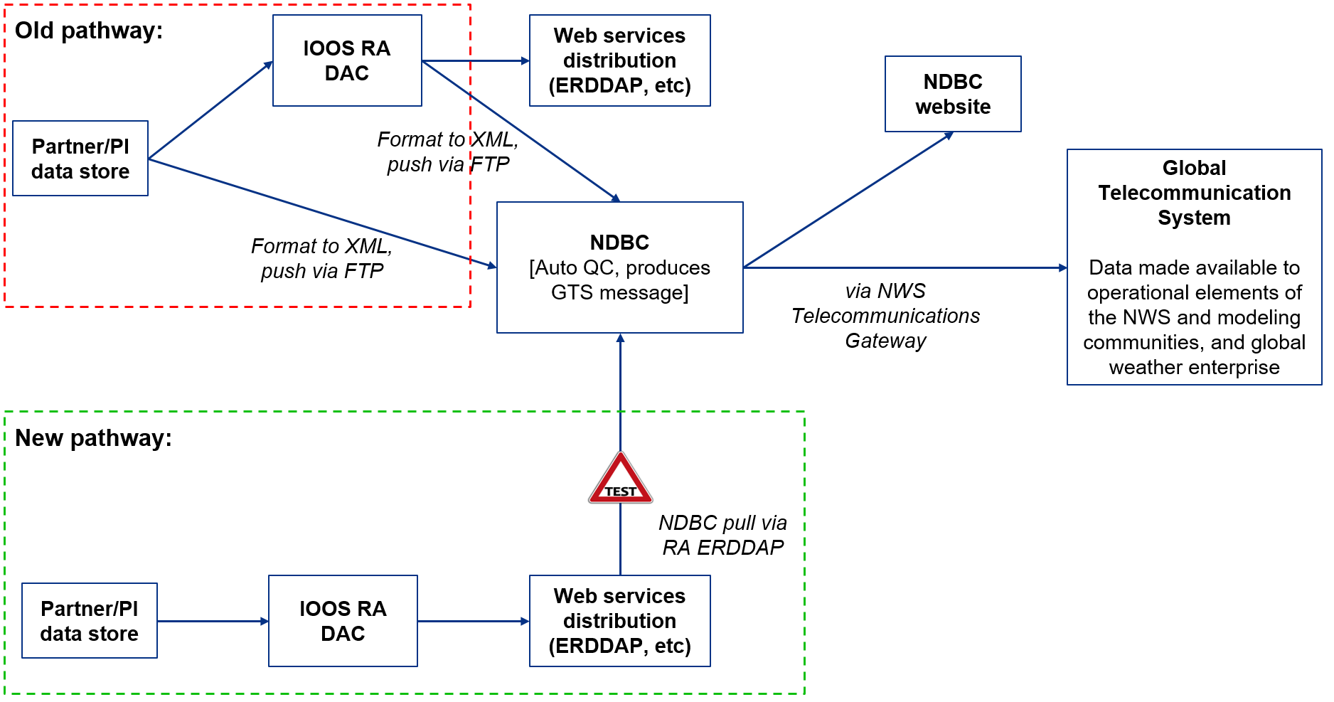
NDBC will leverage IOOS RA ERDDAP servers as the central access points for nonfederal IOOS partner data. This is a departure from the previous data delivery method, where providers and RAs packaged XML files and posted them to an NDBC FTP server. It is critical that RAs work with their regional data providers to ensure their data are available in the RA ERDDAPs, so that NDBC can continue to access those datasets.
In order to allow NDBC to query and filter the correct subset of datasets in an ERDDAP server and process them consistently and predictably, data providers must ensure the following dataset attribution requirements are met.
Refer to the Platform, NDBC/GTS Ingest, and Quality Control/QARTOD tables above for detailed descriptions of the attributes shown below.
For NDBC to pull data for a dataset to the GTS:
- The dataset should be in ERDDAP
- The dataset should meet the Single Platform requirement described in the Platform section
- The dataset should meet requirements for defining the vertical coordinate variable set forth in the Requirements for Vertical Coordinate Variable section
- The dataset should have a global attribute called
wmo_platform_code, with the numeric WMO ID or alphanumeric NWS ID as the value (seewmo_platform_codein the Platform section for details on specific ID requirements) - The dataset should have a global attribute called
gts_ingestwith a value oftrue - Any variables the RA wants to push to NDBC should have an attribute called
gts_ingestwith value oftrue - The variable should have a
standard_nameattribute with a value that’s a valid CF Standard Name. Consult the spreadsheet in the XML to CF Standard Name Mappings section below for Standard Name mappings for specific variables. - The variable should include an ancillary variable representing the QARTOD aggregate flag as defined in the Requirements for the QARTOD Aggregate/Rollup Flag section
- The variable should have a
unitsattribute, with a value that’s a valid unit (that is, the units are convertible to the CF canonical unit using theudunitslibrary)
Note: it is not a requirement for a variable’s QC flag ancillary variables to include a gts_ingest flag.
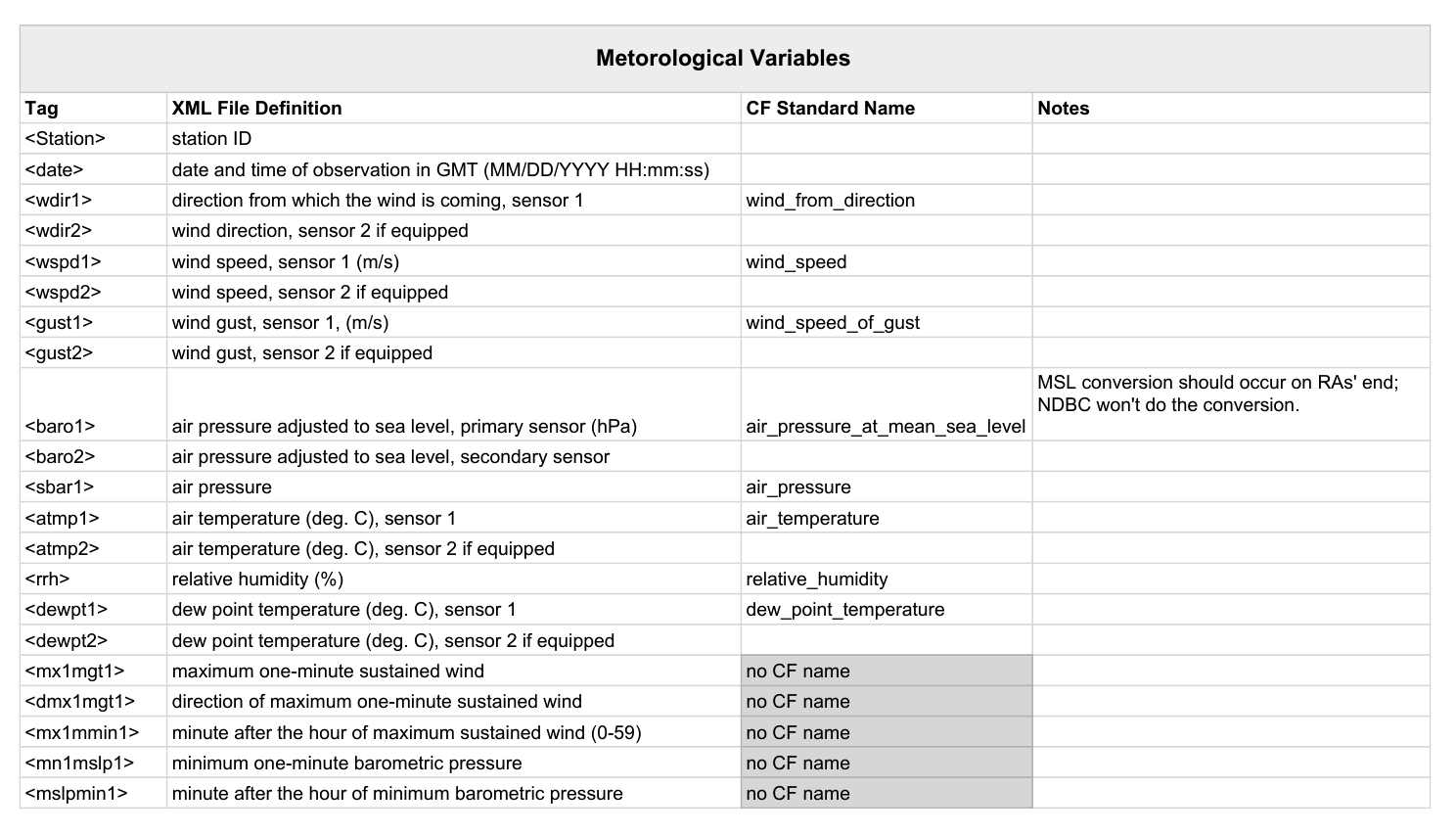
XML to CF Standard Name Mappings: Mappings between the elements, or tags, of the XML file format used for GTS dissemination and the corresponding CF Standard Names to use in ERDDAP variables are found in the spreadsheet below. Note that the file includes additional attribution guidance for certain variables (e.g. salinity) and information about default values that NDBC uses for some elements in derived XML files that RAs typically will not need to address in their own ERDDAP datasets.
Requirements for Vertical Coordinate Variable:
In order for NDBC to be able to uniformly identify and interpret the vertical coordinate variable in IOOS datasets to ensure consistent processing, a specific implementation of the CF guidelines for vertical coordinate variables is necessary. This profile requires the vertical coordinate variable to include the following attributes:
| Name | Accepted Values |
|---|---|
| axis | ‘Z’ |
| positive | ‘up’, down’ |
| units | One of: [meter, meters, inch, foot, yard, mile, miles, US_survey_foot, US_survey_feet, fathom, fathoms, international_inch, international_inches, international_foot, international_feet, international_yard, international_yards, international_mile, international_miles, inches, in, feet, ft, yd, mi] |
Note: The vertical position of an individual observation must always be encoded using the vertical coordinate variable (as specified in the CF DSG guidelines) and cannot be included as an attribute on a data variable.
Requirements for the QARTOD Aggregate/Rollup Flag:
Currently, IOOS RAs push a custom XML format to NDBC for GTS ingestion, so they can exclude “QC fail” values while generating the XML. ERDDAP datasets will have all observed data, including observations marked “QC fail”, so NDBC needs a means to filter QC passing and failing data from the full timeseries. This will be accomplished using an “ancillary variable” according to the CF Ancillary Data guidelines that represents the QC aggregate/rollup flag for each observation variable marked for GTS ingestion, as described below.
Rules governing the ‘Aggregate/Rollup’ flag variable:
- The value of the variable is the UNESCO/QARTOD v2 convention:
- 9 = Missing
- 2 = Not Eval
- 1 = Pass
- 3 = Suspect
- 4 = Fail
- The value of the rollup flag should be the worst result out of all of the individual tests. It’s called a “Summary Flag” in the QARTOD Data Flags manual (pg 3).
- Here’s how it’s done in the ioos_qc library with the corresponding test.
- The variable should have a standard name attribute of
aggregate_quality_flag. See the QARTOD section above for more information. - NDBC should exclude any values that are QC fail (and missing) but include everything else (not eval, pass, suspect)
Notes on NDBC/GTS ingest and QC flagging:
- Although having
gts_ingeston both the dataset itself and each of its variables is redundant, it allows for more efficient querying across a large ERDDAP server - If you set
gts_ingeston a variable that NDBC doesn’t currently accept, NDBC will just ignore it. - RAs may publish ancillary variables with results of individual QC tests, however NDBC will only examine contents of the
aggregate_quality_flagvariable for filtering purposes for GTS harvest. The CF Standard Names table includes several names appropriate for individual QC tests - consult the QARTOD section for the current list.
Examples
The WQB_04 and WQB_05 PacIOOS buoys are actively used by NDBC for collecting data.
Rules for IOOS Asset Identifier Generation
For reference, the IOOS Asset Identifier 1.0 is composed of the following components:
Asset Identifier = urn:ioos:asset_type:authority:label[:component][:discriminant][#functional_parameters]`
The IOOS Asset Identifier can be constructed by combining the Metadata Profile attributes according to their definitions to match the above pattern.
Rules for generating the Asset Identifier from IOOS Metadata Profile attribution:
If platform_id present:
Asset Identifier = 'urn:ioos:' + platform + ':' + naming_authority + ':' + platform_id
If platform_id not present:
Asset Identifier = 'urn:ioos:' + platform + ':' + naming_authority + ':' + id
For datasets with a wmo_platform_code global attribute, a second Asset Identifier is also assumed, according to the following rules:
WMO Asset Identifier = 'urn:ioos:' + platform + ':wmo:' + wmo_platform_code
This means it is possible for a single dataset to have two valid IOOS Asset Identifiers. It is also possible to define as many custom global ‘id’ attributes as necessary. For example, RAs may define their own identification scheme outside those described here, or, if there is another organization (such as NCEI) for which an id is appropriate, it may be included as well (e.g. ncei_id = 123456789 or ncei_accession = 123456789). While these won’t technically be considered to be IOOS Asset Identifiers, there is still the opportunity to identify datasets using community-agreed-upon global identifier attributes.
Additional considerations regarding IOOS Asset Identifiers:
-
At the moment, the specification constrains the valid
asset_types to be: glider, station, network, sensor, and survey. For the purposes of the IOOS Metadata Profile, the values of `platform’ can be more broad, however the resulting Asset Identifiers may not be valid according to that specification. -
If an
instrument_variableis defined for the dataset, it becomes possible for each data variable associated with it (via the:instrumentvariable attribute) to have its own Asset Identifier that is more fully qualified than the global-variable-defined dataset Asset Identifier described above. See the documentation forinstrument_variable:componentandinstrument_variable:discriminantfor details.
IOOS Asset Identifier rules for a dataset with variables that include an instrument_variable reference:
Asset Identifier = 'urn:ioos:' + platform + ':' + naming_authority + ':' + platform_id + ':' + instrument_variable:component + ':' + instrument_variable:discriminant