Acoustic (and Satellite) Telemetry
Overview
Teaching: 15 min
Exercises: 0 minQuestions
How does acoustic telemetry data convert to Darwin Core?
How do I contribute my acoustic telemetry data to OBIS?
Objectives
Collaborating with a network
Understanding the mappings and what metadata and data are important to converting acoustic telemetry to Darwin Core
Contributing tracking data for animals that are monitored with multiple methods of electronic or mark-recapture tracking regimes. (Acoustic, Satellite, RFID, coded-wire)
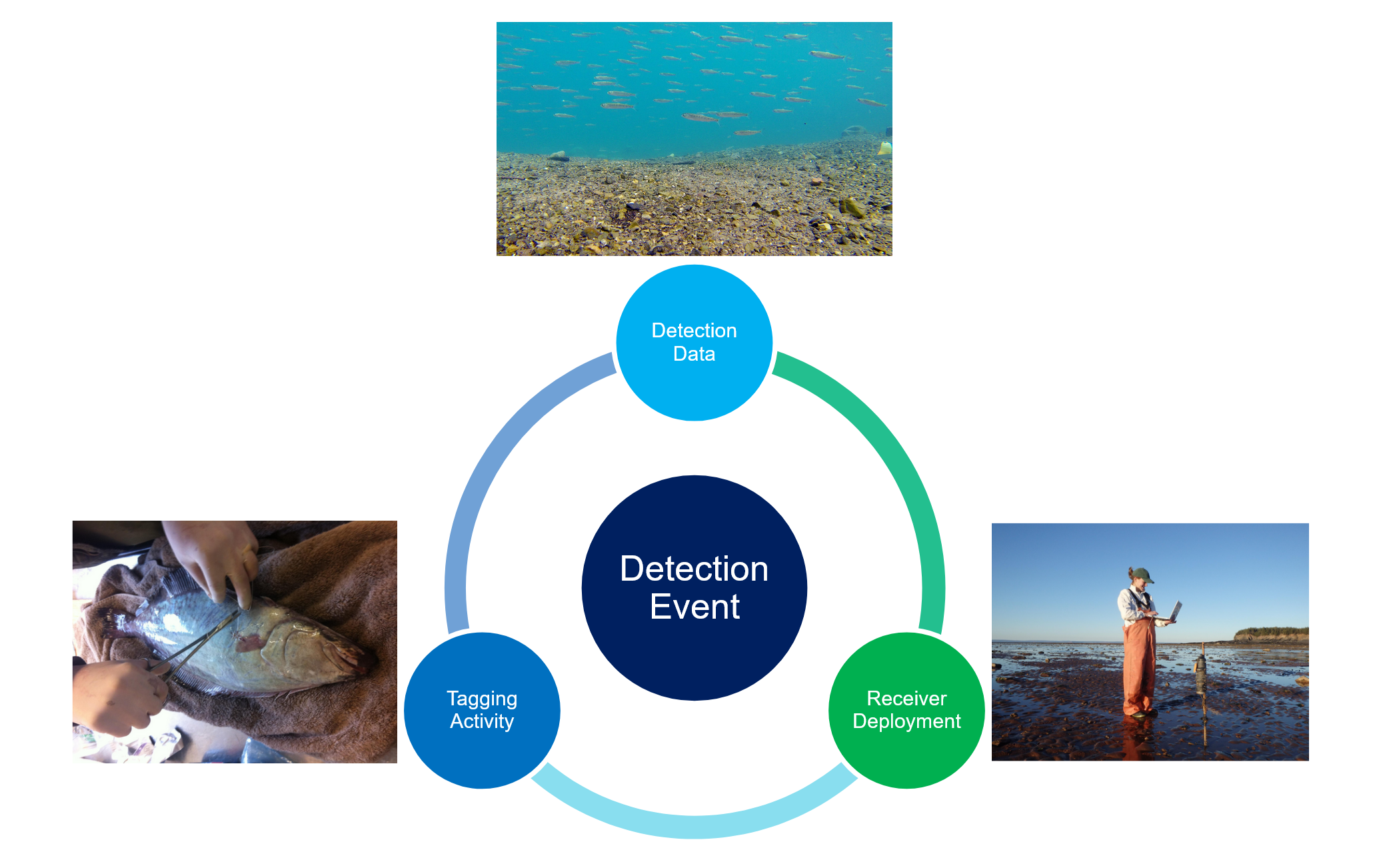
Acoustic and Satellite Telemetry Data
Acoustic Telemetry
How It Works
Acoustic telemetry is a general term that describes the practice of implanting marine animals with electronic tags that emit an identifiable coded set of ‘pings’ to transmit a unique identifier to any listening station that is near enough to record them. Many companies sell systems of coded transmitters (tags) and listening devices (receivers) to allow researchers to track the movements of underwater animals at sub-1km scales. Recent developments allow for many listening stations to synchronize their detection of a ‘ping’ to allow for fine-scale triangulation of animal position.
Networks - getting more data for your tracked animals
Acoustic telemetry equipment is often intercompatible, allowing the listening stations of one project to detect the tagged individuals from any number of other projects. To maximize the utility of their tag detection data and the detectability of their tagged animals, many researchers engaged in acoustic telemetry research contribute their data to a data aggregating network. The global-scale aggregation network for handling and cross-referencing this data is the Ocean Tracking Network, who coordinate many regional networks towards intercompatibility and harmonize the quality control and data pipelines to ensure all networks are able to contribute to a global observation network. Today that network-of-networks has many thousands of listening stations and tracks tens of thousands of active acoustic tags globally. Details on what the Ocean Tracking Network and its partners are currently observing are available at https://members.oceantrack.org/statistics/
Preparing to publish to OBIS - how we solve the many-fish vs. one-fish-many-times problem
Each of the telemetry networks produce for their investigators a data report that takes into account every compatible listening device across all of the networks that has heard their tagged animals. This report is intended to be the best, most complete report available for all possible detections of the studied animals from all participating partners worldwide. These reports can run into the millions of detections for anadromous fish, closed system monitoring, or where an animal may be resident near a listening device (or deceased near one). The Ocean Tracking Network has created a data pipeline for projects that combine all the observations for a certain project into a Darwin Core Event Core archive, based on a shared standard built between the European Tracking Network and the Ocean Tracking Network that can produce an Occurrence Core or Event Core dataset.
When preparing to submit animal telemetry data to the Ocean Biodiversity Information System, we as data managers must consider how to put these tens or hundreds of thousands of individual animal locations into the context of the broader database. By making time-binned summaries of the animal position data, and by using the organismID field to denote multiple positions for a single known individual organism, the OTN publication process allows telemetry data to contribute fully to the OBIS database without creating too much data density or losing the details of each individual animal’s movement history.
Below is a small table highlighting how one might make a time-binned summary of observations. In this example, we truncate the date-times down to the day+hour, then see if there are duplicate values. If so, we keep the first value but drop the other values that fall in that same hour.
Time binning example
time dayhr Keep? 2009-09-23T00:00:00Z 2009-09-23T00 True 2009-09-25T06:42:00Z 2009-09-25T06 True 2009-09-25T11:09:00Z 2009-09-25T11 True 2009-09-25T11:11:00Z 2009-09-25T11 False 2009-09-25T11:30:00Z 2009-09-25T11 False 2009-09-27T17:58:00Z 2009-09-27T17 True 2009-09-30T05:01:00Z 2009-09-30T05 True 2009-10-08T20:24:00Z 2009-10-08T20 True 2009-10-15T11:05:00Z 2009-10-15T11 True 2009-10-17T06:11:00Z 2009-10-17T06 True 2009-10-17T09:00:00Z 2009-10-17T09 True 2009-10-17T10:38:00Z 2009-10-17T10 True 2009-10-18T08:48:00Z 2009-10-18T08 True 2009-10-18T10:26:00Z 2009-10-18T10 True 2009-10-18T11:15:00Z 2009-10-18T11 True 2009-10-19T10:20:00Z 2009-10-19T10 True 2009-10-23T23:52:00Z 2009-10-23T23 True 2009-10-24T00:06:00Z 2009-10-24T00 True 2009-10-26T10:53:00Z 2009-10-26T10 True 2009-10-26T11:22:00Z 2009-10-26T11 True 2009-10-27T16:21:00Z 2009-10-27T16 True 2009-10-27T16:22:00Z 2009-10-27T16 False 2009-10-27T16:42:00Z 2009-10-27T16 False 2009-10-29T11:53:00Z 2009-10-29T11 True 2009-10-30T10:03:00Z 2009-10-30T10 True 2009-10-31T19:48:00Z 2009-10-31T19 True 2009-10-31T21:15:00Z 2009-10-31T21 True 2009-11-01T21:04:00Z 2009-11-01T21 True 2009-11-06T17:53:00Z 2009-11-06T17 True 2009-11-13T18:48:00Z 2009-11-13T18 True 2009-11-23T05:12:00Z 2009-11-23T05 True
Mapping example
OTN maintains this wiki entry example of how to populate each of the Darwin Core fields for an acoustic telemetry-sourced data Darwin Core archive.
https://github.com/tdwg/dwc-for-biologging/wiki/Acoustic-sensor-enabled-tracking-of-blue-sharks
The key features of this schema are:
Metadata:
- Projects are organized around tagging efforts with the related research question and efforts included in the Abstract/Project Description/Sampling Methods fields of the EML.
- Participants are those registered as participating in the tagging project, plus all PIs from the ‘participating’ projects that supplied additional detection events with the role Data Contributor.
Data:
- Event records with associated Occurrence Extension for animal capture (for tagging purposes).
- Event records for tag attachment.
- Event records for receiver deployment (only for ‘participating’ receivers, who have contributed detections to the archive).
- Event records with associated Occurrence Extension for post-filtering detection events at a receiver, one per hour/individual detected.
- Current filtering is the time-based Pincock filtering
- More robust filters are in development, and will include speed and distance filtering, as well as a ‘current known home range’ filter
- Optional eMoF records associated with capture Occurrences describing observed features of the tagged individuals like length, weight, sex, lifestage, etc.
- Optional eMoF records associated with receiver deployments describing any abiotic measurements being made by the receiver unit itself.
- Event records with parent Event records for any co-deployed instruments at a receiver deployment.
- Optional eMoF records associated with the instrument deployment.
Data provided to the Ocean Tracking Network or its Nodes (see https://members.oceantrack.org for the map of current Nodes ) can produce these packages automatically based on currently-reported data. The published datasets are available via OBIS, and OTN’s OBIS Node at https://members.oceantrack.org/ipt/.
Satellite telemetry, light-level geolocation, etc.
Satellite telemetry presumes surfacing events, to allow an instrument to obtain a GPS or Argos network location of a tagged individual. These surfacings are often monitored in near-realtime with a high degree of position error, and paths can be reprocessed and corrected post-deployment using light level geolocation, state-space modelling, or other emerging techniques.
For satellite telemetry, tracks are not published automatically by OTN, but on a case-by-case basis. A method for publishing satellite-based animal telemetry data that conforms to the ETN/OTN standard above as an Occurrence Core archive is explained here: https://github.com/tdwg/dwc-for-biologging/wiki/Movebank-GPS-data. The R package movepub implements this method and its SQL algorithm is also browsable on GitHub for those adapting it to use outside of R. https://github.com/inbo/movepub/blob/main/inst/sql/dwc_occurrence.sql
In the case of working with the IOOS Animal Telemetry Network for satellite telemetry data, tracks will be automatically archived at NOAA’s National Centers for Environmental Information and published to OBIS-USA, as identified by the scientist in the registration system. The mapping between the ATN’s netCDF archival format submitted to NCEI and the Darwin Core format is currently being discussed in this issue.
Multiple-method tagging of animals
Often, animals are tagged with multiple technologies to better capture their movement over smaller and larger distances. The ability to combine both methods into a single file with the same data density and features described above is a very helpful feature of the OTN publication system. Combining the workflows above and harmonizing the many methods of detecting animal position via the organismID field is how we produce a rational combined record of animal position through time, across many methods. Here, the Occurrence/Event detection pair retains and explains the ‘how’ an animal was detected at each point while preserving a complete history for the organism in the Occurrence records.
Sometimes, stranger setups like animals-as-listening-stations or animals collecting oceanographic data can be part of your project. This extends the default schema with some extra components, but nothing is impossible within Event Core!
Providing your telemetry data and metadata to an OTN node
If you want to publish animal telemetry data to OBIS and GBIF, OTN is a thematic OBIS node for animal telemetry and we are able to help you do that. Providing your data to OTN augments it with other potential detections that may have occurred outside your owned listening stations, quality controls the aggregated results, and produces the archive using the QCed metadata and data that you and your collaborators have provided to OTN. These archives are then automatically updated whenever new data or metadata are supplied that extends your project’s dataset. It’s the best way to guarantee there will be an accurate record of your study animals in OBIS now and into the future.
Supplying acoustic or satellite data to OTN or one of its Nodes can be done via our templates at https://members.oceantrack.org/data/data-collection/. Reporting the project metadata provides the information necessary to fulfill the EML metadata, and the Tag/Instrument metadata along with the detection files are the sources of the DwC archive’s Event and Occurrence and eMoF data.
Telemetry for satellite tagged animals can be provided as-is, with an indication of whether it is raw or post-processed.
Key Points
The Ocean Tracking Network is the thematic OBIS node for animal telemetry data.
Mature pipelines exist to take acoustic telemetry data from projects contributing to OTN or to its regional nodes and publish standard, summarized datasets to OBIS.